Make a donation
Gear up for your next adventure:
As an Amazon Associate, this site earns from qualifying purchases at no extra cost to you.
Khor Fakkan topographic map
Click on the map to display elevation.
Make a donation
Gear up for your next adventure:
As an Amazon Associate, this site earns from qualifying purchases at no extra cost to you.
Khor Fakkan
It is also a popular spot among domestic tourists due to its white sand beaches and coral reefs that attract many marine life enthusiasts. Khor Fakkan beach lies to the north of the center of the town. Khor Fakkan is located on the east coast of the UAE, between the Shumayliyah Mountains and the Arabian Sea, with an altitude of 1,023 meters (3,356 ft) at al Hilqah Mountain (Jebel al Hilqah). The bay of Khor Fakkan faces the northeast and is protected from prevailing winds by a jetty serving terminal for container ships. In the mountains of Khor Fakkan and off the Sharjah-Khor Fakkan highway lies the Rifaisa Dam that is considered to have been built over a village, and thus when the water is very quiet, the tops of the old houses are visible. The development of Al Rifaisa Dam spans an area of 10,684 square meters.
Make a donation
Gear up for your next adventure:
As an Amazon Associate, this site earns from qualifying purchases at no extra cost to you.
About this map
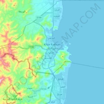
Name: Khor Fakkan topographic map, elevation, terrain.
Location: Khor Fakkan, Sharjah Emirate, United Arab Emirates (25.26057 56.20954 25.42020 56.38129)
Average elevation: 433 ft
Minimum elevation: -13 ft
Maximum elevation: 2,936 ft
Make a donation
Gear up for your next adventure:
As an Amazon Associate, this site earns from qualifying purchases at no extra cost to you.
Other topographic maps
Click on a map to view its topography, its elevation and its terrain.