
Cabedelo topographic map
Click on the map to display elevation.
Cabedelo
It has an area of 29,873 square kilometers, with singular measures: 18 kilometers long and only three kilometers wide. Its population in 2020 was estimated by the Brazilian Institute of Geography and Statistics (IBGE) at 68,767 inhabitants. On 17th century Dutch maps, it appeared as an island because of the Jaguaribe and Mandacaru rivers. Its geophysical age also differs from neighbouring municipalities that tend to have older sedimentary plateaus and therefore divergent average altitude and climate.
About this map
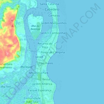
Name: Cabedelo topographic map, elevation, terrain.
Average elevation: 23 ft
Minimum elevation: -30 ft
Maximum elevation: 299 ft