Geolocate

Pflugerville topographic map

Click on the map to display elevation.

About this map

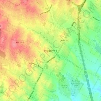
Name: Pflugerville topographic map, elevation, terrain.

Location: Pflugerville, Texas, 78691, United States (30.39937 -97.66000 30.47937 -97.58000)

Average elevation: 719 ft

Minimum elevation: 584 ft

Maximum elevation: 863 ft

Texas trails, hiking, mountain biking, running and outdoor activities

Gear up for your next adventure:

🏫Relief Map Kits - Hands-on tools for teaching landforms and elevation
📦Dry Bags Set - Waterproof storage for electronics and clothes
🔦Compact Flashlight - Reliable flashlight for emergencies
🪶Fire Starter Kit - Reliable fire starter for survival and camping
🧣Merino Neck Gaiters - Multi-functional headwear for wind and sun protection

As an Amazon Associate, this site earns from qualifying purchases at no extra cost to you.