
Make a donation
Gear up for your next adventure:
As an Amazon Associate, this site earns from qualifying purchases at no extra cost to you.
Lapela topographic map
Click on the map to display elevation.
Make a donation
Gear up for your next adventure:
As an Amazon Associate, this site earns from qualifying purchases at no extra cost to you.
About this map
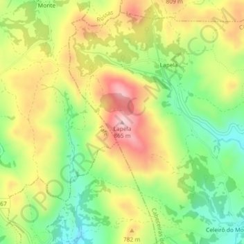
Name: Lapela topographic map, elevation, terrain.
Location: Lapela, Cabeceiras de Basto, Braga, Portugal (41.54609 -8.06106 41.54619 -8.06096)
Average elevation: 2,388 ft
Minimum elevation: 2,008 ft
Maximum elevation: 2,808 ft
Make a donation
Gear up for your next adventure:
As an Amazon Associate, this site earns from qualifying purchases at no extra cost to you.
Other topographic maps
Click on a map to view its topography, its elevation and its terrain.
Refojos de Basto, Outeiro e Painzela
Portugal > Braga > Cabeceiras de Basto
Average elevation: 1,493 ft
Make a donation
Gear up for your next adventure:
As an Amazon Associate, this site earns from qualifying purchases at no extra cost to you.