
Floka topographic map
Interactive map
Click on the map to display elevation.
About this map
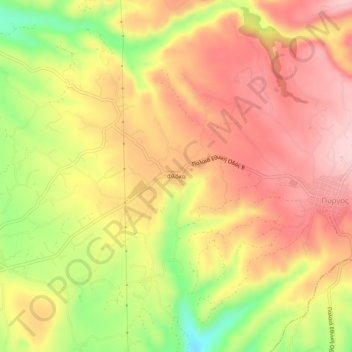
Name: Floka topographic map, elevation, terrain.
Average elevation: 1,096 ft
Minimum elevation: 663 ft
Maximum elevation: 1,381 ft
Other topographic maps
Click on a map to view its topography, its elevation and its terrain.
Marathopoli
Griechenland > Peloponnes, Westgriechenland und Ionische Inseln > Regionalbezirk Messenien > Δημοτική Ενότητα Γαργαλιάνων
Marathopoli, Δημοτική Ενότητα Γαργαλιάνων, Δήμος Τριφυλίας, Regionalbezirk Messenien, Region Peloponnes, Peloponnes, Westgriechenland und Ionische Inseln, 244 00, Griechenland
Average elevation: 59 ft
Βάλτα
Griechenland > Peloponnes, Westgriechenland und Ionische Inseln > Regionalbezirk Messenien > Δημοτική Ενότητα Γαργαλιάνων
Βάλτα, Δημοτική Ενότητα Γαργαλιάνων, Δήμος Τριφυλίας, Regionalbezirk Messenien, Region Peloponnes, Peloponnes, Westgriechenland und Ionische Inseln, 244 00, Griechenland
Average elevation: 715 ft
Gargaliani
Griechenland > Peloponnes, Westgriechenland und Ionische Inseln > Regionalbezirk Messenien > Δημοτική Ενότητα Γαργαλιάνων
Gargaliani, Δημοτική Ενότητα Γαργαλιάνων, Δήμος Τριφυλίας, Regionalbezirk Messenien, Region Peloponnes, Peloponnes, Westgriechenland und Ionische Inseln, 244 00, Griechenland
Average elevation: 633 ft