
Communauté de communes du Grand Pontarlier topographic map
Interactive map
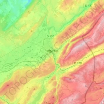
Click on the map to display elevation.
About this map
Name: Communauté de communes du Grand Pontarlier topographic map, elevation, terrain.
Average elevation: 3,120 ft
Minimum elevation: 2,119 ft
Maximum elevation: 4,301 ft
Other topographic maps
Click on a map to view its topography, its elevation and its terrain.
Zone Industrielle
France > Bourgogne-Franche-Comté > Pontarlier
Zone Industrielle, Pontarlier, Doubs, Bourgogne-Franche-Comté, France métropolitaine, 25303, France
Average elevation: 2,697 ft