
Bertrix topographic map
Interactive map
Click on the map to display elevation.
About this map
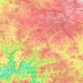
Name: Bertrix topographic map, elevation, terrain.
Location: Bertrix, Neufchâteau, Luxembourg, Wallonia, 6880, Belgium (49.77153 5.15818 49.93189 5.36642)
Average elevation: 1,322 ft
Minimum elevation: 738 ft
Maximum elevation: 1,768 ft
Other topographic maps
Click on a map to view its topography, its elevation and its terrain.
Neufchâteau
Belgium > Luxembourg > Neufchâteau
Neufchâteau, Luxembourg, Wallonia, 6840, Belgium
Average elevation: 1,434 ft
Semois
Belgium > Luxembourg > Neufchâteau > Herbeumont
Semois, Herbeumont, Neufchâteau, Luxembourg, Wallonia, 6887, Belgium
Average elevation: 1,024 ft
Freux
Belgium > Luxembourg > Neufchâteau
Freux, Libramont-Chevigny, Neufchâteau, Luxembourg, Wallonia, Belgium
Average elevation: 1,565 ft
Tombeau Du Géant
Belgium > Luxembourg > Neufchâteau > Bouillon > Ucimont > Botassart
Tombeau Du Géant, Moulin du Rivage, Botassart, Ucimont, Bouillon, Neufchâteau, Luxembourg, Wallonia, 6833, Belgium
Average elevation: 984 ft
Sensenruth
Belgium > Luxembourg > Neufchâteau > Bouillon
Sensenruth, Bouillon, Neufchâteau, Luxembourg, Wallonia, 6832, Belgium
Average elevation: 1,175 ft
Bouillon
Belgium > Luxembourg > Neufchâteau
Bouillon, Neufchâteau, Luxembourg, Wallonia, Belgium
Average elevation: 1,122 ft
Herbeumont
Belgium > Luxembourg > Neufchâteau
Herbeumont, Neufchâteau, Luxembourg, Wallonia, 6887, Belgium
Average elevation: 1,224 ft
Tellin
Belgium > Luxembourg > Neufchâteau
Tellin, Neufchâteau, Luxembourg, Wallonia, 6927, Belgium
Average elevation: 1,017 ft