
Sóller topographic map
Click on the map to display elevation.
About this map
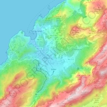
Name: Sóller topographic map, elevation, terrain.
Location: Sóller, Serra de Tramuntana, Balearic Islands, Spain (39.73515 2.66206 39.82337 2.76030)
Average elevation: 1,214 ft
Minimum elevation: -3 ft
Maximum elevation: 3,510 ft
Other topographic maps
Click on a map to view its topography, its elevation and its terrain.
Puig Major
Spain > Balearic Islands > Serra de Tramuntana > Escorca
Puig Major is the highest peak on the Spanish island of Majorca. With an elevation of 1,436 m (4,711 ft) above sea level. It is situated in the Serra de Tramuntana mountains. As the mountain is located in a military zone, the neighbouring peak Puig de Massanella (1,364 m) is considered the highest accessible…
Average elevation: 3,114 ft
Serra de Tramuntana
Spain > Balearic Islands > Serra de Tramuntana
The climate in the Tramuntana Range is significantly wetter than the rest of the island, recording as much as 1507 mm (59.3 inches) of precipitation per year, in comparison with some other parts of the island where annual rainfall is less than 400mm (15 inch). It is also cooler due to the altitude, and a few…
Average elevation: 574 ft
Mirador d'es Colomer
Spain > Balearic Islands > Serra de Tramuntana > Port de Pollença
Average elevation: 259 ft
Cova de ses Bruixes
Spain > Balearic Islands > Serra de Tramuntana > Pollença
Average elevation: 469 ft
Serra de Tramuntana
Spain > Balearic Islands > Serra de Tramuntana
The climate in the Tramuntana Range is significantly wetter than the rest of the island, recording as much as 1507 mm (59.3 inches) of precipitation per year, in comparison with some other parts of the island where annual rainfall is less than 400mm (15 inch). It is also cooler due to the altitude, and a few…
Average elevation: 574 ft