Geolocate

Remire-Montjoly topographic map

Click on the map to display elevation.

About this map
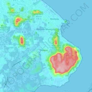
Name: Remire-Montjoly topographic map, elevation, terrain.

Location: Remire-Montjoly, Arrondissement de Cayenne, French Guiana, 97354, France (4.84796 -52.31829 4.93055 -52.24395)

Average elevation: 59 ft

Minimum elevation: -3 ft

Maximum elevation: 571 ft

Other topographic maps

Click on a map to view its topography, its elevation and its terrain.
Crique Gaan Daaye

France > French Guiana > Papaichton

Average elevation: 942 ft

Gear up for your next adventure:

🦟Ultrasonic Repellers - Create a bug-free zone at your camp or rest stop
🪑Ultralight Camp Chairs - Portable seating for resting after a long day of mapping
👓Polarized Sunglasses - Outdoor sunglasses for glare reduction
🎒Outdoor Daypacks - Lightweight backpacks designed for carrying maps and essential gear
🪓Survival Multi‑Tool - Versatile tool for camp and trail tasks

As an Amazon Associate, this site earns from qualifying purchases at no extra cost to you.