
Valle de Bravo topographic map
Interactive map
Click on the map to display elevation.
About this map
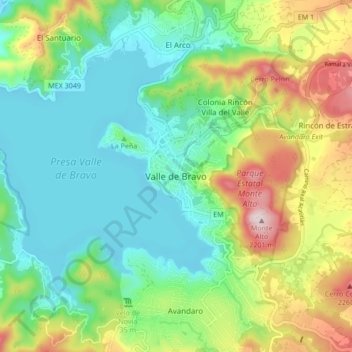
Name: Valle de Bravo topographic map, elevation, terrain.
Location: Valle de Bravo, State of Mexico, 51200, Mexico (19.15426 -100.17166 19.23426 -100.09166)
Average elevation: 6,280 ft
Minimum elevation: 5,817 ft
Maximum elevation: 7,270 ft
The municipality is surrounded by mountain ranges and other elevated areas covering about 50% of the total area and include the Sierra de Temascaltepec, Sierra de Tenayac, Sierra de Valle de Bravos as wells as the hills that roll around the mountain ranges. These elevations include a number of small volcanoes such as the "Cerro Gordo". 30% of the area is semi-flat with only 20% of the surface being plains. The main river of the area is the Río Balsas, whose system includes the tributaries of El Salto, Barranca Honda, Tiloxtoc rivers.