
La Nièvre topographic map
Interactive map
Click on the map to display elevation.
About this map
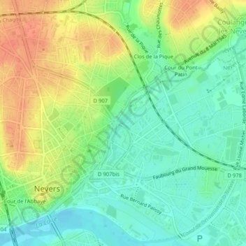
Name: La Nièvre topographic map, elevation, terrain.
Average elevation: 617 ft
Minimum elevation: 551 ft
Maximum elevation: 699 ft
Other topographic maps
Click on a map to view its topography, its elevation and its terrain.
La Baratte
France > Bourgogne-Franche-Comté > Nièvre > Nevers
La Baratte, Nevers, Nièvre, Bourgogne-Franche-Comté, France métropolitaine, 58000, France
Average elevation: 604 ft
Cour de l'Abbaye
France > Bourgogne-Franche-Comté > Nièvre > Nevers
Cour de l'Abbaye, Nevers, Nièvre, Bourgogne-Franche-Comté, France métropolitaine, 58000, France
Average elevation: 620 ft
Cour St Sauveur
France > Bourgogne-Franche-Comté > Nièvre > Nevers
Cour St Sauveur, Nevers, Nièvre, Bourgogne-Franche-Comté, France métropolitaine, 58000, France
Average elevation: 614 ft