
la Coma i la Pedra topographic map
Interactive map
Click on the map to display elevation.
About this map
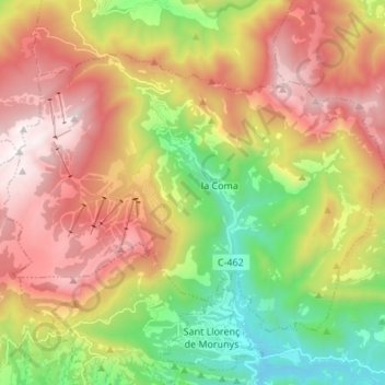
Name: la Coma i la Pedra topographic map, elevation, terrain.
Location: la Coma i la Pedra, Solsonès, Lleida, Catalonia, Spain (42.13750 1.51565 42.21055 1.65093)
Average elevation: 5,046 ft
Minimum elevation: 2,556 ft
Maximum elevation: 7,812 ft
Other topographic maps
Click on a map to view its topography, its elevation and its terrain.