
Kairakau Beach topographic map
Interactive map
Click on the map to display elevation.
About this map
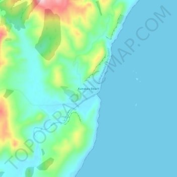
Name: Kairakau Beach topographic map, elevation, terrain.
Average elevation: 151 ft
Minimum elevation: 0 ft
Maximum elevation: 814 ft
Other topographic maps
Click on a map to view its topography, its elevation and its terrain.
Waipawa Hill
New Zealand > Hawke's Bay > Central Hawke's Bay District
Waipawa Hill, Central Hawke's Bay District, Hawke's Bay, 4210, New Zealand
Average elevation: 830 ft
Waipukurau
New Zealand > Hawke's Bay > Central Hawke's Bay District
Waipukurau, Central Hawke's Bay District, Hawke's Bay, 4200, New Zealand
Average elevation: 502 ft
Otane
New Zealand > Hawke's Bay > Central Hawke's Bay District
Otane, Central Hawke's Bay District, Hawke's Bay, 4202, New Zealand
Average elevation: 394 ft
Ongaonga
New Zealand > Hawke's Bay > Central Hawke's Bay District
Ongaonga, Central Hawke's Bay District, Hawke's Bay, New Zealand
Average elevation: 676 ft