
Latitude Margaritaville topographic map
Interactive map
Click on the map to display elevation.
About this map
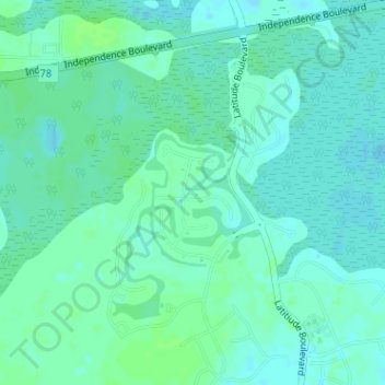
Name: Latitude Margaritaville topographic map, elevation, terrain.
Average elevation: 13 ft
Minimum elevation: -7 ft
Maximum elevation: 26 ft
Other topographic maps
Click on a map to view its topography, its elevation and its terrain.
Hilton Head Lakes North
United States > South Carolina > Jasper County > Hardeeville
Hilton Head Lakes North, Hardeeville, Jasper County, South Carolina, United States
Average elevation: 10 ft
Sun City
United States > South Carolina > Jasper County > Hardeeville
Sun City, Hardeeville, Jasper County, South Carolina, 29909, United States
Average elevation: 20 ft