Geolocate

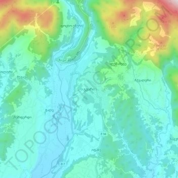
Jvari topographic map

Click on the map to display elevation.

Jvari

Jvari (Georgian: ჯვარი) is a town in the northwestern Georgian province of Samegrelo-Zemo Svaneti. The town is situated at an altitude of 280 metres near the Magana River where it flows into the Enguri River; The town is divided in two with "Jvari" lying on the Zugdidi-Mestia highway, and Jvarzeni (Upper Jvari) up the hill.

Wikipedia (CC-BY-SA 3.0)

About this map

Name: Jvari topographic map, elevation, terrain.

Location: Jvari, Tsalenjikha Municipality, Samegrelo-Upper Svaneti, 5200, Georgia (42.67757 42.00964 42.75757 42.08964)

Average elevation: 1,476 ft

Minimum elevation: 728 ft

Maximum elevation: 4,626 ft

Other topographic maps

Click on a map to view its topography, its elevation and its terrain.

Gear up for your next adventure:

🪑Ultralight Camp Chairs - Portable seating for resting after a long day of mapping
🗺️Topographic Maps - Detailed topo maps for hiking, exploring and outdoor navigation
🧤Tactile Hiking Gloves - Keep hands warm while operating GPS and smartphone screens
🧣Merino Neck Gaiters - Multi-functional headwear for wind and sun protection
👓Polarized Sunglasses - Outdoor sunglasses for glare reduction

As an Amazon Associate, this site earns from qualifying purchases at no extra cost to you.