
Châtillon-en-Michaille topographic map
Interactive map
Click on the map to display elevation.
About this map
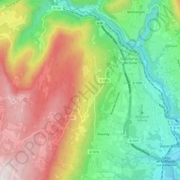
Name: Châtillon-en-Michaille topographic map, elevation, terrain.
Average elevation: 2,201 ft
Minimum elevation: 1,083 ft
Maximum elevation: 4,465 ft
Other topographic maps
Click on a map to view its topography, its elevation and its terrain.
Le Raimont
France > Auvergne-Rhône-Alpes > Ain > Valserhône > Châtillon-en-Michaille > Ochiaz
Le Raimont, Ochiaz, Châtillon-en-Michaille, Valserhône, Nantua, Ain, Auvergne-Rhône-Alpes, Metropolitan France, 01200, France
Average elevation: 3,868 ft
Ochiaz
France > Auvergne-Rhône-Alpes > Ain > Valserhône > Châtillon-en-Michaille
Ochiaz, Châtillon-en-Michaille, Valserhône, Nantua, Ain, Auvergne-Rhône-Alpes, Metropolitan France, 01200, France
Average elevation: 2,359 ft
Ardon
France > Auvergne-Rhône-Alpes > Ain > Valserhône > Châtillon-en-Michaille
Ardon, Châtillon-de-Michaille, Châtillon-en-Michaille, Valserhône, Nantua, Ain, Auvergne-Rhône-Alpes, Metropolitan France, 01200, France
Average elevation: 2,149 ft