
Thatcham topographic map
Interactive map
Click on the map to display elevation.
About this map
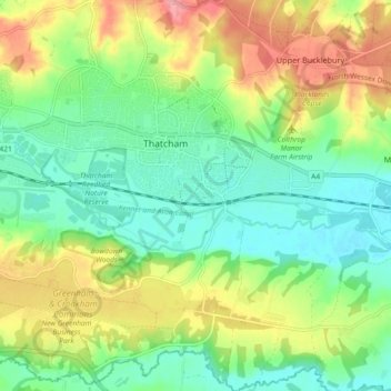
Name: Thatcham topographic map, elevation, terrain.
Location: Thatcham, West Berkshire, England, Vereinigtes Königreich (51.36623 -1.29598 51.42332 -1.20907)
Average elevation: 308 ft
Minimum elevation: 190 ft
Maximum elevation: 499 ft
Other topographic maps
Click on a map to view its topography, its elevation and its terrain.
Combe
Vereinigtes Königreich > England > West Berkshire
Combe, West Berkshire, England, Vereinigtes Königreich
Average elevation: 705 ft
Newbury
Vereinigtes Königreich > England > West Berkshire
Newbury, West Berkshire, England, Vereinigtes Königreich
Average elevation: 318 ft