
Kouroussa Prefecture topographic map
Interactive map
Click on the map to display elevation.
About this map
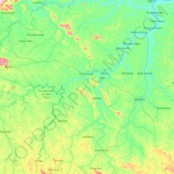
Name: Kouroussa Prefecture topographic map, elevation, terrain.
Location: Kouroussa Prefecture, Kankan Region, Guinea (9.59512 -10.89240 11.42360 -9.28466)
Average elevation: 1,394 ft
Minimum elevation: 1,106 ft
Maximum elevation: 2,848 ft
Other topographic maps
Click on a map to view its topography, its elevation and its terrain.
Safouna-Kankan
Guinea > Kankan Region > Kouroussa Prefecture
Safouna-Kankan, Kouroussa Prefecture, Kankan Region, Guinea
Average elevation: 1,299 ft