
Corning topographic map
Click on the map to display elevation.
About this map
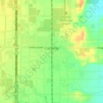
Name: Corning topographic map, elevation, terrain.
Location: Corning, Tehama County, California, 96021, United States (39.90247 -122.20442 39.94975 -122.15984)
Average elevation: 282 ft
Minimum elevation: 230 ft
Maximum elevation: 331 ft
Tehama County trails, hiking, mountain biking, running and outdoor activities
Other topographic maps
Click on a map to view its topography, its elevation and its terrain.
Paskenta
United States > California > Tehama County
Paskenta (Wintun: Paskenti) is a small unincorporated town in Tehama County, California. Historically, it had greater local importance due to the presence of an active lumber mill. The ZIP Code is 96074. The community is inside area code 530 and the Paskenta CDP. Paskenta sits at an elevation of 725 feet (221…
Average elevation: 879 ft