
Hemer topographic map
Interactive map
Click on the map to display elevation.
About this map
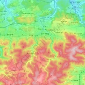
Name: Hemer topographic map, elevation, terrain.
Location: Hemer, Märkischer Kreis, North Rhine-Westphalia, 58675, Germany (51.31223 7.72022 51.41748 7.85342)
Average elevation: 1,070 ft
Minimum elevation: 499 ft
Maximum elevation: 1,795 ft
Hemer is located at the north end of the Sauerland near the Ruhr river. The highest elevation, at 546 metres (1,791 ft), is in the Balver Wald in the south of the city. The lowest elevation, at 160 metres (525 ft), is at the Edelburg in the northeast.
Other topographic maps
Click on a map to view its topography, its elevation and its terrain.
Kierspe
Germany > North Rhine-Westphalia > Märkischer Kreis
Kierspe, Märkischer Kreis, North Rhine-Westphalia, 58566, Germany
Average elevation: 1,339 ft
Dröschede
Germany > North Rhine-Westphalia > Märkischer Kreis > Iserlohn
Dröschede, Iserlohn, Märkischer Kreis, North Rhine-Westphalia, 58644, Germany
Average elevation: 771 ft
Altena
Germany > North Rhine-Westphalia > Märkischer Kreis
Altena, Märkischer Kreis, North Rhine-Westphalia, 58762, Germany
Average elevation: 1,138 ft
Lüdenscheid
Germany > North Rhine-Westphalia > Märkischer Kreis
Lüdenscheid, Märkischer Kreis, North Rhine-Westphalia, Germany
Average elevation: 1,260 ft
Balve
Germany > North Rhine-Westphalia > Märkischer Kreis
Balve, Märkischer Kreis, North Rhine-Westphalia, 58802, Germany
Average elevation: 1,079 ft
Hülseberg
Germany > North Rhine-Westphalia > Märkischer Kreis > Meinerzhagen
Hülseberg, Meinerzhagen, Märkischer Kreis, North Rhine-Westphalia, 58540, Germany
Average elevation: 1,621 ft
Blechen
Germany > North Rhine-Westphalia > Märkischer Kreis > Kierspe > Blechen
Blechen, Kierspe, Märkischer Kreis, North Rhine-Westphalia, 58566, Germany
Average elevation: 1,234 ft
Halver
Germany > North Rhine-Westphalia > Märkischer Kreis
Halver, Märkischer Kreis, North Rhine-Westphalia, 58553, Germany
Average elevation: 1,198 ft