
Pombourg topographic map
Interactive map
Click on the map to display elevation.
About this map
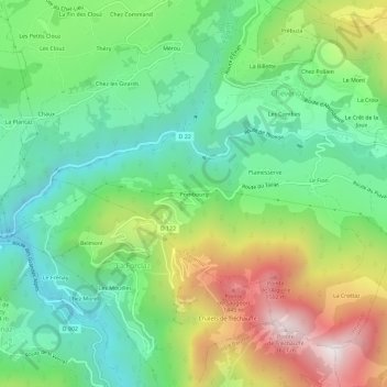
Name: Pombourg topographic map, elevation, terrain.
Average elevation: 3,012 ft
Minimum elevation: 1,775 ft
Maximum elevation: 5,269 ft
Other topographic maps
Click on a map to view its topography, its elevation and its terrain.
Le Mont
France > Auvergne-Rhône-Alpes > Haute-Savoie > Chevenoz
Le Mont, Chevenoz, Thonon-les-Bains, Haute-Savoie, Auvergne-Rhône-Alpes, France métropolitaine, 74500, France
Average elevation: 3,110 ft