
Cehegín topographic map
Interactive map
Click on the map to display elevation.
About this map
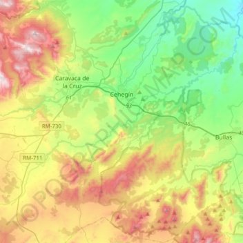
Name: Cehegín topographic map, elevation, terrain.
Location: Cehegín, Noroeste, Region of Murcia, 30430, Spain (37.94497 -1.83329 38.18584 -1.62568)
Average elevation: 2,375 ft
Minimum elevation: 1,053 ft
Maximum elevation: 4,626 ft
Other topographic maps
Click on a map to view its topography, its elevation and its terrain.
Barranda
Spain > Region of Murcia > Noroeste > Caravaca de la Cruz
Barranda, Caravaca de la Cruz, Noroeste, Region of Murcia, 30410, Spain
Average elevation: 2,779 ft
Arroyo Tercero
Spain > Region of Murcia > Noroeste > Moratalla > Arroyo Tercero
Arroyo Tercero, Moratalla, Noroeste, Region of Murcia, Spain
Average elevation: 3,947 ft