
Whitney Lake topographic map
Interactive map
Click on the map to display elevation.
About this map
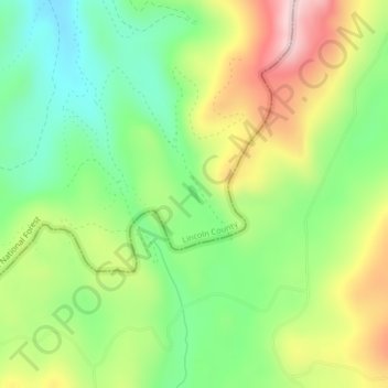
Name: Whitney Lake topographic map, elevation, terrain.
Average elevation: 4,068 ft
Minimum elevation: 3,655 ft
Maximum elevation: 4,662 ft
Other topographic maps
Click on a map to view its topography, its elevation and its terrain.
Rush Lake
États-Unis d'Amérique > Montana > Lincoln County
Rush Lake, Lincoln County, Montana, États-Unis d'Amérique
Average elevation: 2,828 ft
Scenery Mountain
États-Unis d'Amérique > Montana > Lincoln County
Scenery Mountain, Lincoln County, Montana, États-Unis d'Amérique
Average elevation: 5,541 ft