
Nama Khoi Ward 2 topographic map
Interactive map
Click on the map to display elevation.
About this map
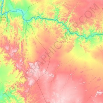
Name: Nama Khoi Ward 2 topographic map, elevation, terrain.
Average elevation: 2,159 ft
Minimum elevation: 443 ft
Maximum elevation: 3,885 ft
Other topographic maps
Click on a map to view its topography, its elevation and its terrain.
Carolusberg
South Africa > Northern Cape > Nama Khoi Local Municipality
Carolusberg, Nama Khoi Local Municipality, Namakwa District Municipality, Northern Cape, South Africa
Average elevation: 3,734 ft