
Make a donation
Gear up for your next adventure:
As an Amazon Associate, this site earns from qualifying purchases at no extra cost to you.
Deçan topographic map
Click on the map to display elevation.
Make a donation
Gear up for your next adventure:
As an Amazon Associate, this site earns from qualifying purchases at no extra cost to you.
Deçan
The altitude in the municipality of Deçan varies from the lowest point in the village of Maznik at 412 m (1,352 ft) to the highest point, which is Gjeravica in the Accursed Mountains, reaching 2,656 m (8,714 ft) above sea level.
Make a donation
Gear up for your next adventure:
As an Amazon Associate, this site earns from qualifying purchases at no extra cost to you.
About this map
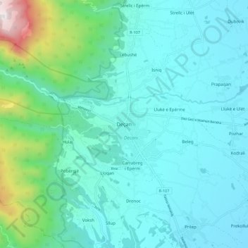
Name: Deçan topographic map, elevation, terrain.
Average elevation: 2,382 ft
Minimum elevation: 1,670 ft
Maximum elevation: 6,158 ft
Make a donation
Gear up for your next adventure:
As an Amazon Associate, this site earns from qualifying purchases at no extra cost to you.