
La Rivière topographic map
Interactive map
Click on the map to display elevation.
About this map
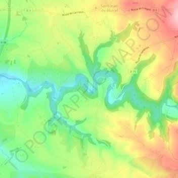
Name: La Rivière topographic map, elevation, terrain.
Location: La Rivière, Albi, Tarn, Occitanie, France métropolitaine, France (44.02079 2.21953 44.06079 2.25953)
Average elevation: 1,115 ft
Minimum elevation: 830 ft
Maximum elevation: 1,470 ft
Other topographic maps
Click on a map to view its topography, its elevation and its terrain.
La Rivière
France > Occitanie > La Rivière
La Rivière, Foix, Ariège, Occitanie, France métropolitaine, France
Average elevation: 1,358 ft
La Rivière
France > Occitanie > La Rivière
La Rivière, Figeac, Lot, Occitanie, France métropolitaine, France
Average elevation: 1,007 ft
La Rivière
France > Occitanie > La Rivière
La Rivière, Auch, Gers, Occitanie, France métropolitaine, France
Average elevation: 725 ft