
Manabí topographic map
Interactive map
Click on the map to display elevation.
About this map
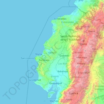
Name: Manabí topographic map, elevation, terrain.
Location: Manabí, Ecuador (-3.31880 -82.62121 1.80120 -77.50121)
Average elevation: 2,201 ft
Minimum elevation: -7 ft
Maximum elevation: 20,095 ft
Other topographic maps
Click on a map to view its topography, its elevation and its terrain.
El Achiote
Ecuador > Manabí > 24 de Mayo
El Achiote, Parroquia Bellavista, 24 de Mayo, Manabí, Ecuador
Average elevation: 430 ft