
Siachen Glacier topographic map
Interactive map
Click on the map to display elevation.
About this map
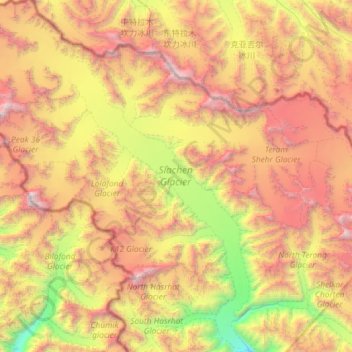
Name: Siachen Glacier topographic map, elevation, terrain.
Location: Siachen Glacier, Leh District, Jammu y Cachemira, India (35.19575 76.75192 35.67020 77.21053)
Average elevation: 17,874 ft
Minimum elevation: 11,699 ft
Maximum elevation: 25,184 ft
Other topographic maps
Click on a map to view its topography, its elevation and its terrain.
Saser Kangri II
Saser Kangri II, Leh District, Jammu y Cachemira, India
Average elevation: 21,345 ft
Sonamarg
India > Jammu y Cachemira > Sonamarg
Sonamarg, Ganderbal, Jammu y Cachemira, India
Average elevation: 11,004 ft
Mamostong Kangri
Mamostong Kangri, Leh District, Jammu y Cachemira, India
Average elevation: 21,535 ft
Ghent Kangri
Ghent Kangri, Leh District, Jammu y Cachemira, India
Average elevation: 21,742 ft
Teram Kangri III
Teram Kangri III, Leh District, Jammu y Cachemira, India
Average elevation: 21,106 ft
Pangong Lake
India > Jammu y Cachemira > Lukung
Pangong Lake, Lukung, Leh District, Jammu y Cachemira, India
Average elevation: 14,413 ft