
Ellicott topographic map
Interactive map
Click on the map to display elevation.
About this map
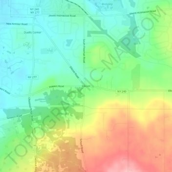
Name: Ellicott topographic map, elevation, terrain.
Average elevation: 1,014 ft
Minimum elevation: 840 ft
Maximum elevation: 1,299 ft
Other topographic maps
Click on a map to view its topography, its elevation and its terrain.
Loveland
United States > New York > Erie County > Town of Orchard Park
Loveland, Town of Orchard Park, Erie County, New York, 14170, United States
Average elevation: 1,066 ft
Webster Corners
United States > New York > Erie County > Town of Orchard Park
Webster Corners, Town of Orchard Park, Erie County, New York, 14127, United States
Average elevation: 801 ft
Windom
United States > New York > Erie County > Town of Orchard Park
Windom, Town of Orchard Park, Erie County, New York, 14219, United States
Average elevation: 712 ft
Duells Corner
United States > New York > Erie County > Town of Orchard Park
Duells Corner, Town of Orchard Park, Erie County, New York, 14127, United States
Average elevation: 889 ft