
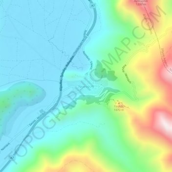
Nestani topographic map
Interactive map
Click on the map to display elevation.
About this map
Name: Nestani topographic map, elevation, terrain.
Average elevation: 2,713 ft
Minimum elevation: 2,044 ft
Maximum elevation: 4,665 ft
It is situated at the foot of the mountain Artemisio, at about 700 m elevation. It was the seat of the former municipality Mantineia. The community Nestani also contains the village of Milea. Nestani is 11 km east of Kapsas, 13 km southwest of Lyrkeia (Argolis) and 14 km northeast of Tripoli. The Moreas Motorway (Corinth–Tripoli-Kalamata/Sparta) passes west of the village.
Other topographic maps
Click on a map to view its topography, its elevation and its terrain.
Tower of Nestani
Greece > Peloponnese, Western Greece and the Ionian > Arcadia Regional Unit > Municipal Unit of Mantineia
Tower of Nestani, Corinth - Tripoli - Kalamata, κ. Σάγκα, Community of Nestani, Municipal Unit of Mantineia, Municipality of Tripoli, Arcadia Regional Unit, Peloponnese Region, Peloponnese, Western Greece and the Ionian, 220 05, Greece
Average elevation: 2,470 ft