
Betong Division topographic map
Interactive map
Click on the map to display elevation.
About this map
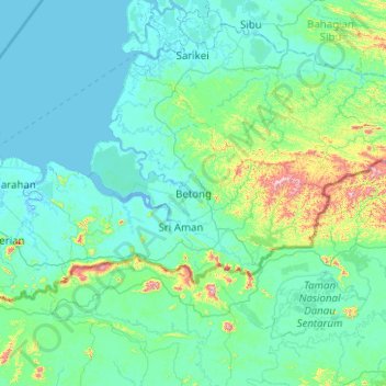
Name: Betong Division topographic map, elevation, terrain.
Location: Betong Division, Betong, Sarawak, Malaysia (0.41159 110.52803 2.41159 112.52803)
Average elevation: 276 ft
Minimum elevation: -13 ft
Maximum elevation: 3,691 ft
Betong Division is divided into three broad topographical regions — the coastal or riverine region, the midland region, and the inland or hilly interior region. The coastal or riverine region is mainly made up of peat swamp with very limited suitable area for agricultural activities in its natural condition. In areas with improved irrigation systems, the soil has gradually improved to enable some agricultural activities to be carried out. Some of the crops planted in the coastal or riverine region are wet paddy, sago, coconuts and perennial crops. Some of the coastal or riverine areas have potential for aquaculture activities such as brackish water fish, tiger prawn and crab cultivation. The midland region has more suitable areas for agricultural activities. Crops such as pepper, rubber, paddy, and oil palm are planted in the midland region. Most of the livestock and pond fish rearing are also found in this region. All the commercial livestock in the division area are in this region. The inland or hilly interior region is mountainous with steep terrain and only pockets of the areas are cultivated with hilly paddy, pepper and rubber.