
Kettle River topographic map
Interactive map
Click on the map to display elevation.
About this map
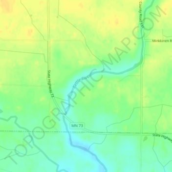
Name: Kettle River topographic map, elevation, terrain.
Location: Kettle River, Carlton County, Minnesota, 55757, USA (46.51087 -92.90384 46.51552 -92.89590)
Average elevation: 1,204 ft
Minimum elevation: 1,161 ft
Maximum elevation: 1,243 ft
Other topographic maps
Click on a map to view its topography, its elevation and its terrain.
St. Louis Park
USA > Minnesota > St. Louis Park
St. Louis Park, Hennepin County, Minnesota, USA
Average elevation: 902 ft
Cathedral Hill Park
USA > Minnesota > Saint Paul
Cathedral Hill Park, Saint Paul, Ramsey County, Minnesota, USA
Average elevation: 827 ft
St. Michael
USA > Minnesota > St. Michael
St. Michael, Wright County, Minnesota, 55376, USA
Average elevation: 951 ft
Alexandria
USA > Minnesota > Alexandria
Alexandria, Douglas County, Minnesota, 56308, USA
Average elevation: 1,398 ft
Keller Lake
Keller Lake, North Maplewood Drive, Maplewood, Ramsey County, Minnesota, 55109, USA
Average elevation: 892 ft
Brooklyn Center
USA > Minnesota > Brooklyn Center
Brooklyn Center, Hennepin County, Minnesota, USA
Average elevation: 863 ft
Medicine Lake
USA > Minnesota > Medicine Lake
Medicine Lake, Hennepin County, Minnesota, USA
Average elevation: 902 ft