
Ann Arbor topographic map
Interactive map
Click on the map to display elevation.
About this map
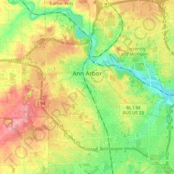
Name: Ann Arbor topographic map, elevation, terrain.
Location: Ann Arbor, Washtenaw County, Michigan, United States (42.22267 -83.79957 42.32389 -83.67581)
Average elevation: 879 ft
Minimum elevation: 732 ft
Maximum elevation: 1,070 ft
Ann Arbor is 11.2 miles (18.0 km) road miles west of Ypsilanti. Ann Arbor is also 42.1 miles (67.8 km) road miles west of Detroit. Ann Arbor Charter Township adjoins the city's north and east sides. Ann Arbor is situated on the Huron River in a productive agricultural and fruit-growing region. The landscape of Ann Arbor consists of hills and valleys, with the terrain becoming steeper near the Huron River. The elevation ranges from about 750 feet (230 m) along the Huron River to 1,015 feet (309 m) on the city's west side, near the intersection of Maple Road and Pauline Blvd. Generally, the west-central and northwestern parts of the city and U-M's North Campus are the highest parts of the city; the lowest parts are along the Huron River and in the southeast. Ann Arbor Municipal Airport, which is south of the city at 42°13.38′N 83°44.74′W / 42.22300°N 83.74567°W / 42.22300; -83.74567, has an elevation of 839 feet (256 m).
Other topographic maps
Click on a map to view its topography, its elevation and its terrain.
Ypsilanti
United States > Michigan > Washtenaw County
Ypsilanti, Washtenaw County, Michigan, 48197, United States
Average elevation: 755 ft
Freedom Township
United States > Michigan > Washtenaw County
Freedom Township, Washtenaw County, Michigan, United States
Average elevation: 951 ft
Saline
United States > Michigan > Washtenaw County
Saline, Washtenaw County, Michigan, 48176, United States
Average elevation: 814 ft
Bridgewater Township
United States > Michigan > Washtenaw County
Bridgewater Township, Washtenaw County, Michigan, United States
Average elevation: 879 ft
Ann Arbor Charter Township
United States > Michigan > Washtenaw County
Ann Arbor Charter Township, Washtenaw County, Michigan, 48107, United States
Average elevation: 883 ft
Lodi Township
United States > Michigan > Washtenaw County
Lodi Township, Washtenaw County, Michigan, United States
Average elevation: 902 ft
Dexter
United States > Michigan > Washtenaw County
Dexter, Washtenaw County, Michigan, United States
Average elevation: 886 ft
Ypsilanti Charter Township
United States > Michigan > Washtenaw County
Ypsilanti Charter Township, Washtenaw County, Michigan, 48198, United States
Average elevation: 748 ft
Truman Lake
United States > Michigan > Washtenaw County > Saline Township
Truman Lake, Saline Township, Washtenaw County, Michigan, United States
Average elevation: 863 ft
Blind Lake
United States > Michigan > Washtenaw County > Lyndon Township
Blind Lake, Lyndon Township, Washtenaw County, Michigan, United States
Average elevation: 906 ft
Manchester
United States > Michigan > Washtenaw County
Manchester, Manchester Township, Washtenaw County, Michigan, United States
Average elevation: 928 ft
Salem Township
United States > Michigan > Washtenaw County > Salem Township
Salem Township, Washtenaw County, Michigan, 48175, United States
Average elevation: 928 ft
Pittsfield Charter Township
United States > Michigan > Washtenaw County
Pittsfield Charter Township, Washtenaw County, Michigan, United States
Average elevation: 840 ft
Augusta Township
United States > Michigan > Washtenaw County
Augusta Township, Washtenaw County, Michigan, 48191, United States
Average elevation: 686 ft
Milan
United States > Michigan > Washtenaw County
Milan, Washtenaw County, Michigan, 48160, United States
Average elevation: 699 ft
Fourmile Lake
United States > Michigan > Washtenaw County > Lima Township
Fourmile Lake, Lima Township, Washtenaw County, Michigan, 48118, United States
Average elevation: 902 ft