
Make a donation
Gear up for your next adventure:
As an Amazon Associate, this site earns from qualifying purchases at no extra cost to you.
Ypsilanti topographic map
Click on the map to display elevation.
Make a donation
Gear up for your next adventure:
As an Amazon Associate, this site earns from qualifying purchases at no extra cost to you.
About this map
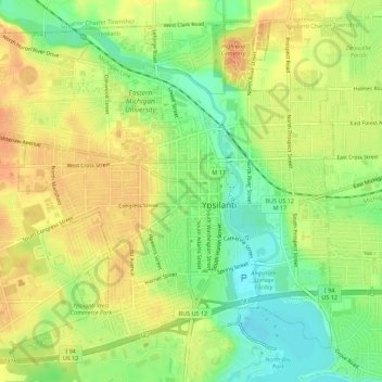
Name: Ypsilanti topographic map, elevation, terrain.
Location: Ypsilanti, Washtenaw County, Michigan, United States (42.22418 -83.65208 42.26087 -83.59643)
Average elevation: 755 ft
Minimum elevation: 676 ft
Maximum elevation: 823 ft
Washtenaw County trails, hiking, mountain biking, running and outdoor activities
Make a donation
Gear up for your next adventure:
As an Amazon Associate, this site earns from qualifying purchases at no extra cost to you.
Other topographic maps
Click on a map to view its topography, its elevation and its terrain.
Mooreville
United States > Michigan > Washtenaw County > York Charter Township
Average elevation: 728 ft
Rawsonville
United States > Michigan > Washtenaw County > Ypsilanti Charter Township
Average elevation: 702 ft
Rawsonville
United States > Michigan > Washtenaw County > Ypsilanti Charter Township
Average elevation: 702 ft
Make a donation
Gear up for your next adventure:
As an Amazon Associate, this site earns from qualifying purchases at no extra cost to you.
Frain Lake
United States > Michigan > Washtenaw County > Superior Charter Township
Average elevation: 850 ft
Rawsonville
United States > Michigan > Washtenaw County > Ypsilanti Charter Township
Average elevation: 702 ft