
Bermiego topographic map
Interactive map
Click on the map to display elevation.
About this map
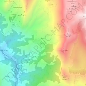
Name: Bermiego topographic map, elevation, terrain.
Location: Bermiego, Quirós, Asturië, 33118, Spanje (43.18024 -5.99782 43.22024 -5.95782)
Average elevation: 3,009 ft
Minimum elevation: 1,096 ft
Maximum elevation: 5,476 ft
Other topographic maps
Click on a map to view its topography, its elevation and its terrain.
Las Agüeras
Spanje > Asturië > Quirós > Las Agüeras
Las Agüeras, Quirós, Asturië, 33118, Spanje
Average elevation: 2,175 ft