
Nogent-le-Rotrou topographic map
Interactive map
Click on the map to display elevation.
About this map
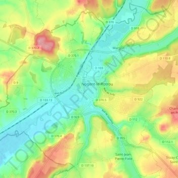
Name: Nogent-le-Rotrou topographic map, elevation, terrain.
Average elevation: 476 ft
Minimum elevation: 322 ft
Maximum elevation: 702 ft
Nogent-le-Rotrou liegt am Fluss Huisne im Regionalen Naturpark Perche in einer Höhe von ca. 115 m. Nächstgrößere Städte sind Chartres (ca. 60 km nordöstlich), Le Mans (ca. 65 km südwestlich) und Alençon (ca. 65 km nordwestlich). Das Klima ist in hohem Maße vom Meer beeinflusst und deshalb nahezu frostfrei; Regen (ca. 655 mm/Jahr) fällt verteilt übers ganze Jahr.