
La Yesa topographic map
Interactive map
Click on the map to display elevation.
About this map
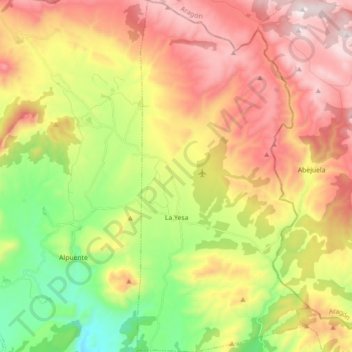
Name: La Yesa topographic map, elevation, terrain.
Location: La Yesa, La Serranía, Valencia, Comunidad Valenciana, España (39.83916 -0.98153 39.97574 -0.89506)
Average elevation: 3,789 ft
Minimum elevation: 2,346 ft
Maximum elevation: 5,322 ft
Other topographic maps
Click on a map to view its topography, its elevation and its terrain.
Picarcho
España > Comunidad Valenciana > La Serranía > Tuéjar
Picarcho, Tuéjar, La Serranía, Valencia, Comunidad Valenciana, España
Average elevation: 3,602 ft