Geolocate

Warren topographic map

Click on the map to display elevation.

About this map
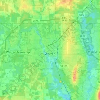
Name: Warren topographic map, elevation, terrain.

Location: Warren, Trumbull County, Ohio, United States (41.21086 -80.89400 41.27205 -80.74052)

Average elevation: 909 ft

Minimum elevation: 843 ft

Maximum elevation: 1,063 ft

Trumbull County trails, hiking, mountain biking, running and outdoor activities

Other topographic maps

Click on a map to view its topography, its elevation and its terrain.
Howland Township

United States > Ohio > Trumbull County

Average elevation: 981 ft

Vienna

United States > Ohio > Trumbull County

Average elevation: 1,122 ft

Vienna Township

United States > Ohio > Trumbull County

Average elevation: 1,122 ft

Burghill

United States > Ohio > Trumbull County > Vernon Township

Average elevation: 1,020 ft

Gear up for your next adventure:

🪓Survival Multi‑Tool - Versatile tool for camp and trail tasks
🧼Biodegradable Camping Soap - Eco‑friendly soap for outdoor hygiene
⛺Backpacking Tent - Lightweight and durable tent for multi‑day hikes
🛰️Handheld GPS Units - Professional satellite navigators for precise backcountry mapping
🗺️NatGeo Topo Maps - High-quality waterproof printed topographic maps of US Parks

As an Amazon Associate, this site earns from qualifying purchases at no extra cost to you.