Geolocate

Nîmes topographic map

Click on the map to display elevation.

About this map
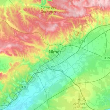
Name: Nîmes topographic map, elevation, terrain.

Location: Nîmes, Gard, Occitania, Metropolitan France, France (43.74127 4.23567 43.92302 4.44966)

Average elevation: 295 ft

Minimum elevation: 46 ft

Maximum elevation: 702 ft

Other topographic maps

Click on a map to view its topography, its elevation and its terrain.
Esparon

France > Occitania > Gard > Bez-et-Esparon

Average elevation: 1,713 ft

Mas Berthaud

France > Occitania > Gard > Saint-Gilles

Average elevation: 13 ft

Les Mazes

France > Occitania > Gard > Village de Sérignac

Average elevation: 308 ft

Les Brousses

France > Occitania > Gard > Molières-sur-Cèze

Average elevation: 961 ft

Mont Aigoual

France > Occitania > Gard > Val-d'Aigoual

Average elevation: 4,446 ft

la Croix

France > Occitania > Gard > Argilliers > Argilliers

Average elevation: 299 ft

Escalade

France > Occitania > Gard > Sumène

Average elevation: 1,220 ft

Camp Bernard

France > Occitania > Gard > Val-d'Aigoual > Fenouillet

Average elevation: 2,087 ft

Le Soulier

France > Occitania > Gard > Saint-Martin-de-Valgalgues

Average elevation: 663 ft

Bay

France > Occitania > Gard > Canaules-et-Argentières

Average elevation: 322 ft

Résidence le Mattas

France > Occitania > Gard > Méjannes-le-Clap

Average elevation: 863 ft

Le Fageas

France > Occitania > Gard > L'Estréchure

Average elevation: 2,802 ft

Gear up for your next adventure:

🥩Freeze-Dried Meals - Nutritious and lightweight food for remote expeditions
🪶Survival Guide Book - Expert advice for emergency preparedness
🎁Geography Themed Gifts - Unique gift ideas for map lovers and geography enthusiasts
🌐World Map Poster - Decorative world maps with topographic info
🏔️Mountain Trail Maps - High‑detail maps for popular peaks

As an Amazon Associate, this site earns from qualifying purchases at no extra cost to you.