
Make a donation
Gear up for your next adventure:
As an Amazon Associate, this site earns from qualifying purchases at no extra cost to you.
Hattfjelldal topographic map
Click on the map to display elevation.
Make a donation
Gear up for your next adventure:
As an Amazon Associate, this site earns from qualifying purchases at no extra cost to you.
About this map
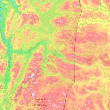
Name: Hattfjelldal topographic map, elevation, terrain.
Location: Hattfjelldal, Nordland, Norway (65.10829 13.62555 65.89172 14.62548)
Average elevation: 2,257 ft
Minimum elevation: 3 ft
Maximum elevation: 5,564 ft
Make a donation
Gear up for your next adventure:
As an Amazon Associate, this site earns from qualifying purchases at no extra cost to you.
Other topographic maps
Click on a map to view its topography, its elevation and its terrain.
Bodø
Snow cover during winter varies, and is often sparse or lacking in the city center, while being more reliable only slightly inland or at some altitude. The largest recorded snow depth at the airport is 90 centimetres (35 in) in February 1976. Located on a peninsula in the Norwegian Sea, Bodø is known to be a…
Average elevation: 243 ft