Geolocate

Bitche topographic map

Click on the map to display elevation.

About this map
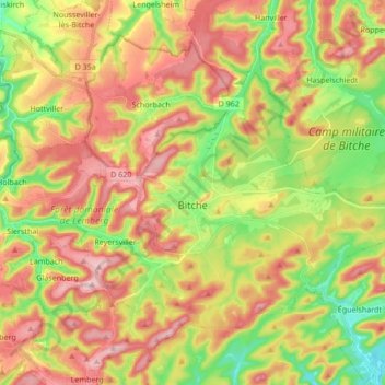
Name: Bitche topographic map, elevation, terrain.

Location: Bitche, Sarreguemines, Moselle, Grand Est, Metropolitan France, 57230, France (49.01530 7.38859 49.09385 7.55797)

Average elevation: 1,086 ft

Minimum elevation: 761 ft

Maximum elevation: 1,401 ft

Other topographic maps

Click on a map to view its topography, its elevation and its terrain.
Everst Garten

France > Grand Est > Moselle > Villing > Trois Maisons

Average elevation: 938 ft

Saint-Pierremont

France > Grand Est > Moselle > Marsal

Average elevation: 745 ft

Grand Soldat

France > Grand Est > Moselle > Abreschviller

Average elevation: 1,391 ft

Eschwiller Mill

France > Grand Est > Moselle > Eschviller

Average elevation: 988 ft

Fourneau Neuf

France > Grand Est > Moselle > Mouterhouse

Average elevation: 925 ft

Falkenstein Castle

France > Grand Est > Moselle > Philippsbourg

In 1981, the Vosges Club (club vosgien) in Strasbourg placed a marker at the castle summit showing the altitude and directions to nearby land features.

Average elevation: 883 ft
Metzing

France > Grand Est > Moselle > Riche

Average elevation: 774 ft

Kapellenhof

France > Grand Est > Moselle > Hottviller

Average elevation: 1,056 ft

Holbach

France > Grand Est > Moselle

Average elevation: 1,086 ft

Mont Saint-Quentin

France > Grand Est > Moselle > Scy-Chazelles

Average elevation: 778 ft

Singling

France > Grand Est > Moselle

Average elevation: 1,070 ft

Hautes Phrases

France > Grand Est > Moselle > Château-Salins

Average elevation: 797 ft

Crème

France > Grand Est > Moselle > Obreck

Average elevation: 748 ft

Mont Saint-Quentin

France > Grand Est > Moselle > Scy-Chazelles

Average elevation: 778 ft

Moor

France > Grand Est > Moselle > Loudrefing

Average elevation: 791 ft

Audviller

France > Grand Est > Moselle > Wentzviller

Average elevation: 748 ft

Gear up for your next adventure:

☀️Outdoor Sunscreen - High protection sunscreen for outdoor activities
❄️Traction Cleats - Prevent slips on icy trails during winter hikes
🪶Multi‑Purpose Knife - Useful blade for camp and trail
🗺️Topographic Maps - Detailed topo maps for hiking, exploring and outdoor navigation
🗺️NatGeo Topo Maps - High-quality waterproof printed topographic maps of US Parks

As an Amazon Associate, this site earns from qualifying purchases at no extra cost to you.