
Ambato topographic map
Interactive map
Click on the map to display elevation.
About this map
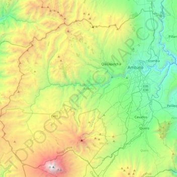
Name: Ambato topographic map, elevation, terrain.
Location: Ambato, Tungurahua, Ecuador (-1.47092 -78.93798 -1.10980 -78.53680)
Average elevation: 11,811 ft
Minimum elevation: 7,372 ft
Maximum elevation: 20,518 ft
Other topographic maps
Click on a map to view its topography, its elevation and its terrain.
Ambato
Ecuador > Tungurahua > Ambato > Ambato
Ambato, Tungurahua, 0838, Ecuador
Average elevation: 10,318 ft
Pillaro
Ecuador > Tungurahua > Pillaro
Pillaro, Santiago de Pillaro, Tungurahua, Ecuador
Average elevation: 9,354 ft