
Salé topographic map
Interactive map
Click on the map to display elevation.
About this map
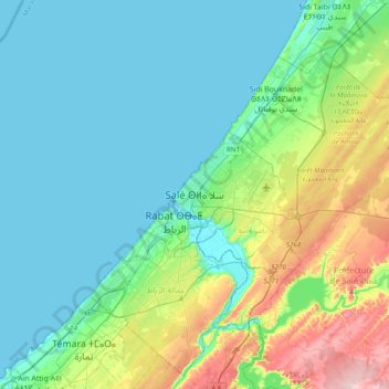
Name: Salé topographic map, elevation, terrain.
Average elevation: 174 ft
Minimum elevation: -7 ft
Maximum elevation: 794 ft
Other topographic maps
Click on a map to view its topography, its elevation and its terrain.
Résidence du roi du Maroc
Maroc > Pachalik de Salé > Salé
Résidence du roi du Maroc, RN6, Salé, Layayda, Pachalik de Salé, Préfecture de Salé, Rabat-Salé-Kénitra, 11012, Maroc
Average elevation: 338 ft
Parc Hay Salam
Maroc > Pachalik de Salé > Salé
Parc Hay Salam, Moulay Ismail, Salé, Pachalik de Salé, Préfecture de Salé, Rabat-Salé-Kénitra, Maroc
Average elevation: 210 ft