
Harvestehude topographic map
Interactive map
Click on the map to display elevation.
About this map
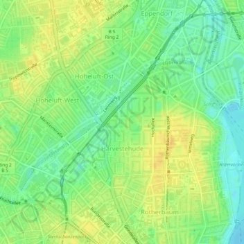
Name: Harvestehude topographic map, elevation, terrain.
Location: Harvestehude, Eimsbüttel, Hamburg, Deutschland (53.57146 9.97025 53.58525 10.00485)
Average elevation: 52 ft
Minimum elevation: 7 ft
Maximum elevation: 89 ft
Die Abrisse historischer Bausubstanz erreichten in den 1970er-Jahren in Harvestehude ihren Höhepunkt. Meist wichen Villen auf großen Grundstücken Appartementkomplexen. Auch heute noch kommt es immer wieder vor, dass historische Bausubstanz abgerissen wird, beispielsweise zuletzt im Sommer 2007 eine Villa des so genannten „romantischen Historismus“ aus den 1850er-Jahren am Mittelweg.
Other topographic maps
Click on a map to view its topography, its elevation and its terrain.
Volksdorf
Deutschland > Hamburg > Hamburg
Volksdorf, Wandsbek, Hamburg, 22359, Deutschland
Average elevation: 138 ft
Rotherbaum
Deutschland > Hamburg > Hamburg
Rotherbaum, Eimsbüttel, Hamburg, Deutschland
Average elevation: 49 ft