
Woluwe topographic map
Interactive map
Click on the map to display elevation.
About this map
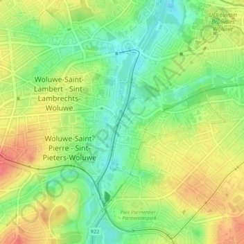
Name: Woluwe topographic map, elevation, terrain.
Location: Woluwe, Woluwe-Saint-Lambert, Bruxelles-Capitale, 1200, Belgique (50.83977 4.43647 50.83996 4.43669)
Average elevation: 213 ft
Minimum elevation: 121 ft
Maximum elevation: 308 ft
Other topographic maps
Click on a map to view its topography, its elevation and its terrain.
Parc Georges Henri
Belgique > Bruxelles-Capitale > Woluwe-Saint-Lambert
Parc Georges Henri, Woluwe-Saint-Lambert, Bruxelles-Capitale, 1200, Belgique
Average elevation: 236 ft