Geolocate

Mottarone topographic map

Click on the map to display elevation.

Mottarone

Mottarone is a mountain in the Western Alps of Piedmont, north-western Italy, with an elevation of 1,492 metres (4,895 ft). It is located between the provinces of Verbano-Cusio-Ossola and Novara.

Wikipedia (CC-BY-SA 3.0)

About this map

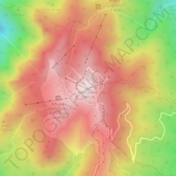
Name: Mottarone topographic map, elevation, terrain.

Location: Mottarone, Stresa, Valstrona, Verbano-Cusio-Ossola, Piedmont, 28882, Italy (45.88149 8.45384 45.88159 8.45394)

Average elevation: 3,862 ft

Minimum elevation: 2,297 ft

Maximum elevation: 4,882 ft

Gear up for your next adventure:

🥾Men's Hiking Boots - Durable, waterproof footwear for rugged terrain and steep inclines
🌡️Handheld Weather Meters - Measure wind, temp, and pressure for safe mountain travel
🥇GPS Hiking Watch - Multi‑sport GPS watch with navigation and trail tracking
🥤Water Filter Bottle - All‑in‑one filter bottle for safe hydration
🪓Survival Multi‑Tool - Versatile tool for camp and trail tasks

As an Amazon Associate, this site earns from qualifying purchases at no extra cost to you.