
Ararat Province topographic map
Interactive map
Click on the map to display elevation.
About this map
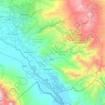
Name: Ararat Province topographic map, elevation, terrain.
Location: Ararat Province, Armenia (39.71388 44.31613 40.19180 45.11717)
Average elevation: 4,724 ft
Minimum elevation: 2,612 ft
Maximum elevation: 16,732 ft
Other topographic maps
Click on a map to view its topography, its elevation and its terrain.
Aygepat
Aygepat, Artashat region, Ararat Province, 0713, Armenia
Average elevation: 2,808 ft