
Make a donation
Gear up for your next adventure:
As an Amazon Associate, this site earns from qualifying purchases at no extra cost to you.
Ilagan topographic map
Click on the map to display elevation.
Make a donation
Gear up for your next adventure:
As an Amazon Associate, this site earns from qualifying purchases at no extra cost to you.
Ilagan
Abuan River is the main river of the Northern Sierra Madre Natural Park. It has an average elevation of 82 meters above sea level, and feeds the Abuan watershed in the city. Tourists and visitors can explore the diverse animal and plant life in one of the country’s remaining lush virgin forests. On January 9, 2024, the city government of Ilagan ordered the temporary closure of Abuan River and its surrounding areas to all picnics and recreational activities to give way for its planned rehabilitation and development. On March 11, 2024, after more than a month since its closure, the officials of the city government led the reopening of the newly-rehabilitated tourist spot. It was later on rebranded and renamed as Abuan River Adventure and Eco-Tourism Park. Additional facilities/amenities for water adventure rides like kayaks, boats, jet-ski, All-Terrain Vehicles (ATVs), paragliding, LED/solar lights, steel cottages and comfort rooms were added to lure more local tourists and visitors from neighboring towns and provinces.
Make a donation
Gear up for your next adventure:
As an Amazon Associate, this site earns from qualifying purchases at no extra cost to you.
About this map
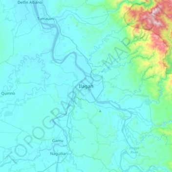
Name: Ilagan topographic map, elevation, terrain.
Location: Ilagan, Isabela, Cagayan Valley, 3300, Philippines (16.98863 121.72865 17.30863 122.04865)
Average elevation: 404 ft
Minimum elevation: 72 ft
Maximum elevation: 3,579 ft
Make a donation
Gear up for your next adventure:
As an Amazon Associate, this site earns from qualifying purchases at no extra cost to you.
Other topographic maps
Click on a map to view its topography, its elevation and its terrain.
Make a donation
Gear up for your next adventure:
As an Amazon Associate, this site earns from qualifying purchases at no extra cost to you.
Make a donation
Gear up for your next adventure:
As an Amazon Associate, this site earns from qualifying purchases at no extra cost to you.
Make a donation
Gear up for your next adventure:
As an Amazon Associate, this site earns from qualifying purchases at no extra cost to you.
Make a donation
Gear up for your next adventure:
As an Amazon Associate, this site earns from qualifying purchases at no extra cost to you.