
Le Moulin topographic map
Interactive map
Click on the map to display elevation.
About this map
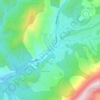
Name: Le Moulin topographic map, elevation, terrain.
Average elevation: 4,478 ft
Minimum elevation: 3,753 ft
Maximum elevation: 6,496 ft
Other topographic maps
Click on a map to view its topography, its elevation and its terrain.
Le Haut Vernet
France > Provence-Alpes-Côte d'Azur > Alpes-de-Haute-Provence > Le Vernet
Le Haut Vernet, Le Vernet, Digne-les-Bains, Alpes-de-Haute-Provence, Provence-Alpes-Côte d'Azur, France métropolitaine, 04140, France
Average elevation: 4,534 ft
Col du Labouret
France > Provence-Alpes-Côte d'Azur > Alpes-de-Haute-Provence > Le Vernet
Col du Labouret, Le Vernet, Digne-les-Bains, Alpes-de-Haute-Provence, Provence-Alpes-Côte d'Azur, France métropolitaine, 04140, France
Average elevation: 4,147 ft