
Make a donation
Gear up for your next adventure:
As an Amazon Associate, this site earns from qualifying purchases at no extra cost to you.
Le Peûtet topographic map
Click on the map to display elevation.
Make a donation
Gear up for your next adventure:
As an Amazon Associate, this site earns from qualifying purchases at no extra cost to you.
About this map
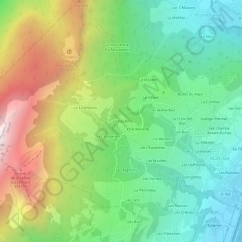
Name: Le Peûtet topographic map, elevation, terrain.
Average elevation: 3,136 ft
Minimum elevation: 1,204 ft
Maximum elevation: 6,552 ft
Make a donation
Gear up for your next adventure:
As an Amazon Associate, this site earns from qualifying purchases at no extra cost to you.
Other topographic maps
Click on a map to view its topography, its elevation and its terrain.
Fort de Lestal
France > Auvergne-Rhône-Alpes > Savoie > Marthod > La Combaz
Le fort est situé au nord d'Albertville, pour bloquer une tentative de passage par Beaufort et le col des Saisies. Il a été aménagé sur les pentes d'un contrefort du massif des Bauges (la Dent de Cons, culminant à 2 062 mètres d'altitude), surplombant ainsi Ugine, le val d'Arly vers le nord-est avec la…
Average elevation: 1,886 ft